
Insights into the management of the road assets of England’s Strategic Road Network – webinar recording
Back in June, TRL Software released a major update to its world-leading iROADS™ asset management platform. In his latest blog, iROADS™ Product Owner John Proust highlights a couple of innovative features that literally take the software to a new dimension.
One thing that we regularly hear from our customers is how much they appreciate the visual clarity of our products, and that was something on which we focused ahead of our latest update release in June. Accurate, reliable and useful data is, of course, essential to any infrastructure management software but it is also increasingly important that users can view that data in a manner that is easy to interpret and readily understandable for key decision makers within their organisations.
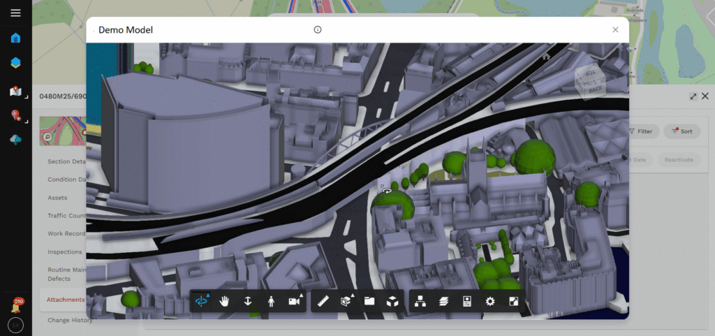
One of the most visually striking iROADS™ features is our CAD Viewer, which enables the viewing of CAD files stored within iROADS™ in both 2D and 3D formats – an important enhancement now that three-dimensional design models are increasingly being used alongside their two-dimensional predecessors. iROADS™ provides industry-standard tools for users to view and work with these 3D objects – extending the software’s capabilities beyond road asset management and into the wider construction ecosystem. We’ve also added photogrammetry capabilities to process digital images into high-resolution textured meshes, dense point clouds and orthophotos – all from within iROADS™. The result is that customers don’t need separate applications to view or work with these files, and can make full use of richly detailed and fully explorable 3D models of their assets and the surrounding roadscape. These technologies are already widely used in the construction sector and by bringing them into the field of operations, we are helping to bridge what has historically been something of a gap between the two sectors. I believe that we are only scratching the surface of the potential use cases this will help to open up.
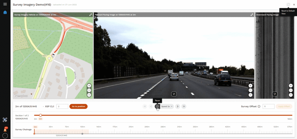
As well as mapping and monitoring the roads within their networks, iROADS™ customers can now also ‘drive’ those roads from the comfort of their desks, with our Road Vision feature which allows users to play back images captured via vehicle surveys. This capability supports both forward- and downward-facing imagery, allowing virtual drivers to choose between a ‘regular’ driver view of their roads or an eyes-down close-up look at the state of their paved surfaces. Road Vision controls just like any video player, making it easy and intuitive to use, and syncs up with a map view so that users can accurately locate what they are seeing.
 Beyond these improved visual capabilities, iROADS™ also boasts an enhanced user experience, supported by a number of less visible improvements ‘beneath the bonnet’ of the software. These include:
- Role-based data access restrictions giving admin users more control over which users can view and/or edit different types of data
- SMS notifications for customers who wish to receive instant updates when road-users report roadway issues via the iROADS™ public mobile app
- Single sign-on support, along with improved user account management features
- Improved clarity and usability of the ‘import templates’ feature, making it easier for users to load their data into the system
- Improved options for exporting road network data
- A refined user experience and interface for the uploading of asset-related documents
Many of the above improvements have been conceived and developed based on the specific needs and wishes of our existing customers, with whom we have been working closely on the iROADS™ companion public mobile app. We are now looking forward to working with our other customers and seeing how their specific business requirements can also be used to further improve future iterations of iROADS™.
We would of course love to hear from any of our customers – and, indeed, any prospective new customers – who would like to know more about iROADS™. If you’d like to get in touch, please contact the team at [email protected]
Related News


